
Nautical Sextant: What is it and how to use it?
22 May 2023
NEWS | Industry, Sailing
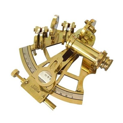
The marine or nautical sextant is a tool used in maritime navigation for centuries.
It is a measuring instrument that makes it possible to determine the position of a vessel in the ocean by observing the stars. Although modern technology has brought with it more accurate positioning systems, the sextant is still used by amateur navigators and astronomers because of its simplicity and reliability.
Knowing how to use it allows us to measure the angular separation between two objects such as two points (usually were the horizon and the coast) and calculate the position of a ship at sea. It consists of a graduated arc and a movable arm holding a mirror and a viewer that can obtain the angular height of the sun above the horizon.
The observation of the stars, such as the sun, the moon, the planets or the stars, through the sextant when navigating makes it possible to determine the angular height of these bodies in relation to the horizon.
How do you use a sextant for navigation?
Imagine you are on a ship and you want to know where you are in the ocean. To do this, you need to know your latitude, that is, how far you are from the equator. Here's a simple explanation of the steps to follow:
-Observation: The first step is to select a celestial object, such as the Sun or a bright star. You point the sextant at the object and look at it through the scope.
-Alignment: Next, you adjust the nautical sextant so that the celestial object and the horizon line up in the viewfinder. This is accomplished by moving a mirror on the instrument until the celestial object is reflected in it and coincides with the horizon line you see in the scope.
-Measurement: Now comes the important part. The sextant has a scale graduated in degrees. Using a movable arm, you measure the angle between the celestial object and the horizon. To do this, you move the arm until the celestial object is reflected in the mirror and appears on a fixed part of the graduated scale.
-Calculation: With the measured angle, you can use nautical tables or formulas to convert it into a latitude reading. These tables will give you the information you need to determine your position in the ocean.
An example of a very basic calculation is the formula for the semimeridian:
Latitude = 90° - Angular height of the object + Declination of the object.
Detailing the formula we have:
- Angular height of the object: It is the angle measured with the sextant between the celestial object (for example, the Sun) and the horizon.
- Declination of the object: It is the angle at which the celestial object is in relation to the celestial equator. It can be found in nautical tables or calculated using other formulas.
To perform the calculation you must first make sure you have the correct values for the angular height and declination of the object. Then simply substitute those values into the formula and perform the calculation. The result will give you the approximate latitude of your position in the ocean.
It is important to note that there are other, more accurate formulas and methods for calculating latitude using a nautical sextant, and in practice specific tables are used for each celestial object and its position in the sky at a given time. These tables provide corrections and additional factors to obtain more accurate results.
Advantages of navigating with a sextant
The nautical sextant offers independence, accuracy, historical connection and learning opportunities. Although more advanced technologies are available today, this instrument remains a valued tool for sailors seeking a traditional and reliable way to determine their position on the ocean.
- Independence from technology: Unlike electronic navigation systems, a navigation sextant does not depend on electricity, batteries or satellite signals. This means you can determine your position in the ocean even in situations where modern technology may fail or be unavailable.
- Latitude accuracy: They allow you to accurately measure the angular height of celestial objects. This provides a reliable way to determine the latitude of your position at sea, which is critical for navigation.
- Connection to nautical tradition: Their use is rooted in the history of navigation and connects modern navigators to the techniques used by previous generations. Sailing with a nautical sextant provides a unique experience and a sense of connection to sailors of the past.
- Skill development: Using one requires practice and knowledge of the principles of astronomical navigation. By learning to use a marine sextant, you develop skills of observation, calculation and understanding of celestial phenomena. These skills can be valuable in emergency situations or when navigating in remote areas where electronic navigation systems may not be reliable.
What kind of technology is used today?
Currently, the most commonly used technology in maritime navigation is GPS. GPS systems allow precise determination of a vessel's position using a network of satellites in orbit around the Earth.
These systems provide real-time information on the location, speed and direction of the vessel.
Other electronic instruments, such as radar and satellite communication systems, are also used to improve safety and efficiency in navigation. Although modern technology has revolutionized maritime navigation, the sextant is still a tool appreciated for its simplicity and credibility, and continues to be used by amateur navigators and astronomers.
Finally, its knowledge and mastery are important for emergency situations and as a way of keeping alive the tradition and art of navigation through the stars. As we move forward in the age of technology, the nautical sextant represents a link between the past and present of maritime navigation.


_v2.svg)
_v2.svg)


_v2.svg)